Page Navigation
Planning Scheme User Guide
What are the components of the Somerset Region Planning Scheme?
The Somerset Region Planning Scheme Version Two has been amended in accordance with the Alignment Amendment Rules to align with the Planning Act 2016 and incorporates the regulated requirements of the Planning Regulation 2017.
The earlier Somerset Regional Planning Scheme was guided by the Queensland Planning Provisions (QPP), which provided a standard format for every planning scheme in Queensland.
The components of the Somerset Region Planning Scheme are:
Part 1. About the planning scheme - Introduces the planning scheme, interpretation, standards and definitions. It also introduces categories of development, hierarchy of assessment benchmarks and administrative matters.
Part 2. State Planning Provisions - Identifies how the regional plan and other state planning policies interact with the Somerset Region Planning Scheme.
Part 3. Strategic Framework - Sets the policy direction for the planning scheme and forms the basis for ensuring appropriate development is carried out for the life of the planning scheme.
Part 4. Priority Infrastructure Plan (PIP) - The priority infrastructure plan has been prepared in accordance with the requirements of the Sustainable Planning Act 2009.
Part 5. Tables of Assessment - The tables in this part identify the categories of development and assessment and assessment benchmarks for development within the planning scheme area.
Part 6. Zones - Zones organize the planning scheme area in a way that facilitates the location of preferred or acceptable land uses. Zones are mapped and included in Schedule 2.
Part 7. Overlays - Identify areas within the planning scheme that reflect state and local level interests and that have specific characteristics such as; particular sensitivity to the effects of development, constraints on land use or development, presence of valuable resources or particular opportunities for development.
Part 8. Development Codes - Development codes are codes for assessment where identified as an applicable code in part 5.
How the scheme works
What needs approval?
Most development will potentially be subject to planning scheme requirements and may need planning approval. The planning scheme applies to the following types of development defined by the Planning Act 2016:
- Building work assessable against the planning scheme- eg. building a shed on vacant land.
- Material change of use - start/restart of a new/abandoned use and or increase in intensity or scale of an existing use.
- Operational work - e.g. earth works or vegetation clearing.
- Reconfiguring a lot e.g. subdivision, boundary realignment, creating an access easement.
How to use this scheme
Material change of use
Step 1: Use Table SC1.1.2-Use definitions in the Somerset Regional Planning Scheme Version Two to determine the planning scheme definition which best fits what you want to do. If what you intend to do is not listed in table SC1.1.2, check table SC1.2.1-Administrative terms and definitions. If what you intend to do is not listed in either table, it will most likely be an undefined use and you should contact Council’s planning staff.
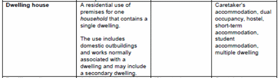
Figure 1
Step 2: Use Council’s zone mapping (available online through eServices or hard copy at service centers) to determine what zone and/or precinct applies to your land.
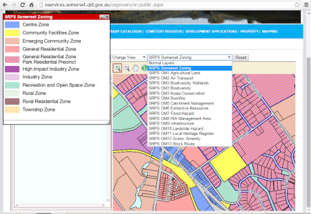
Figure 2
Step 3: Once you know your zone and use definition, you can find the correct table in Part 5 - Tables of assessment to determine the provisional categories of development and assessment and relevant requirements and assessment benchmarks which will apply to your proposal and zone.
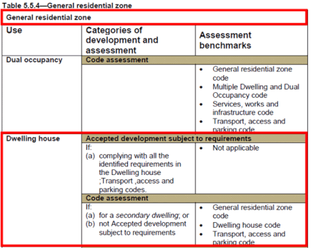
Figure 3
In the example above, a dwelling house would not need a planning approval (accepted development subject to requirements) provided it complied exactly with the requirements identified in the second column but would need a planning approval (code assessment) where it did not or was for/included a granny flat (secondary dwelling).
Step 4: The provisional category of assessment and development could change if one of the scheme’s overlays affects your land. To identify what, if any, overlays apply to your land, repeat step 2 but this time apply the overlays one by one in the drop-down menu.
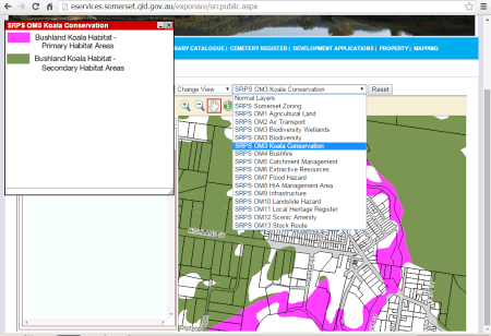
Figure 4
Step 5: Once you know whether any overlays apply to your land, you will be able to find the appropriate table in Part 5 - Tables of assessment (beginning at table 5.9.1) and determine whether the overlay affects the provisional category of development and assessment.
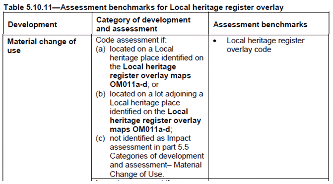
Figure 5
In the example above, a dwelling house would require a planning approval (code assessment) if the site was identified on the local heritage register overlay or if the site was next to an identified local heritage place.
Step 6: Using the relevant zone and overlay tables of assessment in Part 5, you can now locate the applicable zone codes in Part 6, development codes in Part 8 and overlay codes in Part 7 which would apply to your proposal.
For our example above in figures 3 and 5, the dwelling house on land identified in the Local heritage register overlay will need to comply with the General residential zone code in part 6, Dwelling house code in part 8.2, the Transport, access and parking code in part 8.3 and the Local heritage overlay code in part 7.
Reconfiguring a lot
Step 1: Go to Table 5.6.1 in Part 5 - Tables of assessment. The categories of development and assessment will depend on the zone and the nature of the reconfiguration.
Step 2: Use Council’s zone mapping (available online through eServices or hard copy at service centres) to determine what zone or precinct applies to your land.

Figure 6
Step 3: Using the zone, you will now be able to determine the provisional category of development and assessment for your proposal.
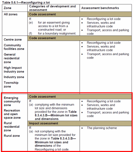
Figure 7
In this case, a subdivision would require a planning approval (code assessment) provided the proposed lots comply with the minimum lot size identified in the Reconfiguring a lot code. The application would require public notification and need to be assessed against all relevant parts of the planning scheme (Impact assessment) if proposed lots did not comply with the minimum lot sizes.
Step 4: Unlike for a material change of use, all applications for reconfiguring a lot will require a planning approval and none of the overlays will alter the categories of development and assessment. However, if an overlay applies to your property then the application will need to address the relevant provisions of the overlay code. To identify what, if any, overlays apply to your land repeat step 2 but this time applying the overlays in the drop-down menu.
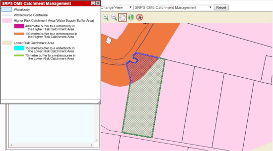
Figure 8
Step 5: Once you know whether any overlays apply to your land, you will be able to find the appropriate table in Part 5 - Tables of assessment (beginning at table 5.9.1) and determine what, if any, overlay codes will be relevant to your application. The example above (hatched area) shows that the land is subject to the Catchment Management Overlay.
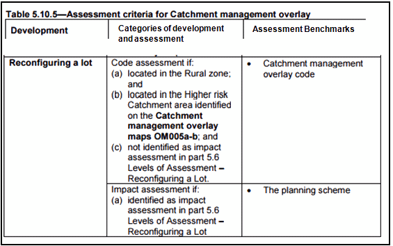
Figure 9
In the example above, a subdivision would need to address the requirements of the Catchment management overlay code.
Step 6:
Using the relevant zone and overlay tables of assessment in Part 5, you can now locate the applicable zone codes in Part 6, development codes in Part 8 and overlay codes in Part 7.
For our example above in Figures 7 and 9, a subdivision consistent with the minimum lot sizes in the Reconfiguring a lot code would need to demonstrate compliance with the Reconfiguring a lot code, Transport, access and parking code, Services, works and infrastructure code in part 9.4 and the Catchment management overlay code in part 8.
Operational Work
Step 1: Go to Table 5.8.1 in Part 5 levels of assessment. The category of development and assessment will depend on the zone and the nature of the operational work.
Step 2: Use Council’s zone mapping (available online through eServices mapping or hard copy at service centres) to determine what zone and/or precinct applies to your land.

Figure 10
Step 3: Using the zone, you will now be able to determine the provisional category of development and assessment for your proposal.
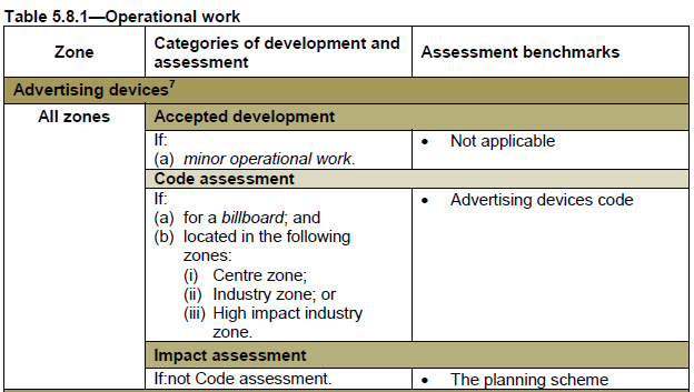
Figure 11
In the example above, a billboard in the Centre zone would require a planning approval and would need to demonstrate compliance with the code identified in column 3 (Code assessment).
Step 4: Most operational work will require a planning approval and most of the overlays will not alter the level of assessment. To identify what, if any, overlays apply to your land repeat step 2 but this time applying the overlays in the drop-down menu.
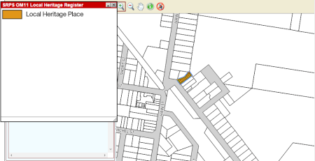
Figure 12
Step 5: Once you know whether any overlays apply to your land, you will be able to find the appropriate table in Part 5 - Levels of assessment (beginning at Table 5.9.1) and determine whether the overlay affects the provisional level of assessment.
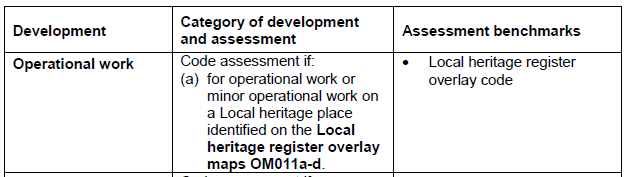
Figure 13
In the example above, a billboard on land identified on the Local heritage register overlay would still require a planning approval.
Step 6:
Using the relevant zone and overlay tables of assessment in Part 5, you can now locate the applicable zone codes in Part 6, development codes in Part 8 and overlay codes in Part 9.
For our example above in Figure 11 and Figure 13, a billboard to be erected on land in the Centre Zone and identified on the Local heritage register overlay would need to demonstrate compliance with the Advertising devices code from Part 9.4 and the Local heritage overlay code from Part 8.
Building Work assessable against the Planning Scheme
Step 1: Use Table SC1.2.2 - Administrative terms and definitions in the Somerset Region Planning Scheme Version Two to determine the definition which best fits what you want to do.
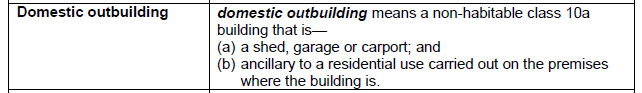
Figure 14

Figure 15
Step 2: Use Council’s zone mapping (available online through eServices or hard copy at service centres) to determine what zone or precinct applies to your land.
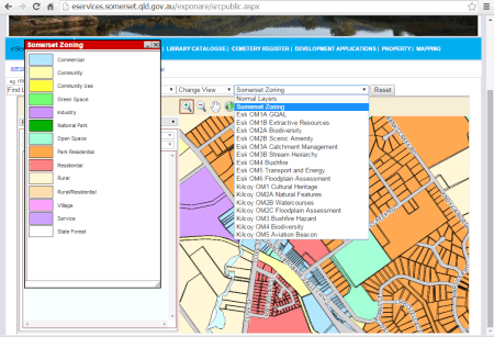
Figure 16
Step 3: Using the zone, you will now be able to determine the provisional category of development and assessment for your proposal by going to Table 5.7.1 in Part 5 – Tables of assessment.
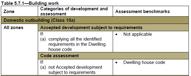
Figure 17
In the example above, a shed ancillary to a dwelling house would not require a planning approval (accepted development subject to requirements) provided it complies exactly with the requirements of the code identified in the second column but would require a planning approval if it did not comply with those parts of the code.
Step 4: The provisional category of development and assessment could change if one of the scheme’s overlays affects your land. To identify what, if any, overlays apply to your land repeat step 2 but this time applying the overlays in the drop-down menu.
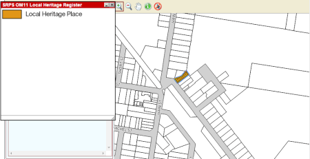
Figure 18
Step 5: Once you know whether any overlays apply to your land, you will be able to find the appropriate table in Part 5 - Tables of assessment (beginning at table 5.9.1) and determine whether the overlay affects the provisional category of development and assessment.
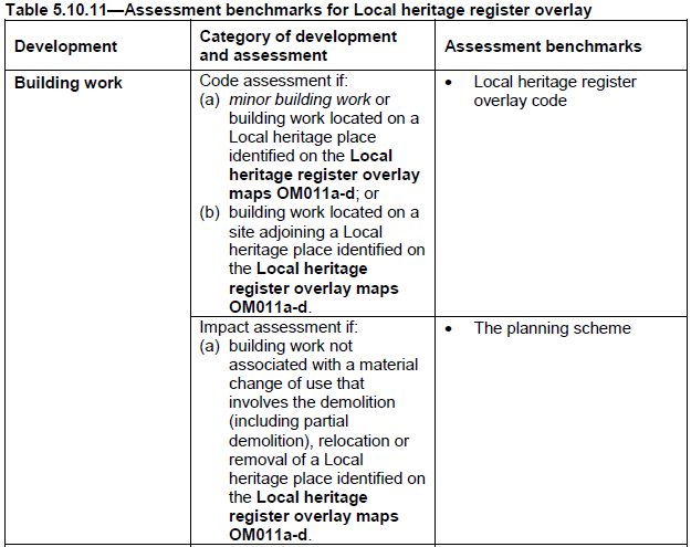
Figure 19
In the example above, a shed ancillary to a dwelling house identified on land subject to the local heritage register overlay maps which did not involve the demolition, relocation or removal of a local heritage place would require a planning approval and would need to demonstrate compliance with the requirements of the Local heritage overlay register code.
Step 6: Using the relevant zone and overlay tables of assessment in part 5, you can now locate the applicable zone codes in part 6, development codes in part 8 and overlay codes in part 7.
Need more information?
This user guide is intended to assist in using the planning scheme to work out if the development you propose to undertake will require planning approval. For further information please contact Council on (07) 5424 4000 or email mail@somerset.qld.gov.au. Additional information can also be obtained from the Somerset Region Planning Scheme and the Sustainable Planning Act 2009.